G’day, I’m Ernie. If you’ve checked the Auckland Council GeoMaps lately, you might have noticed some new blue lines across your section. As a builder and flood restorer, I’ve seen how these updated models are changing the game for local homeowners.
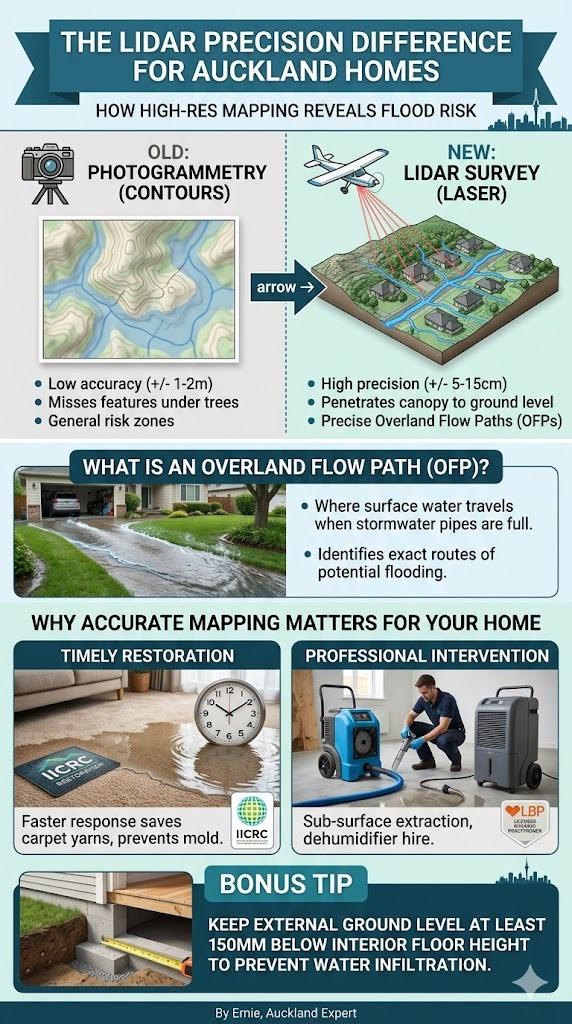
Auckland’s flood models use LiDAR technology to map overland flow paths with precision. These updates reflect topographic changes, helping homeowners identify flood risks and manage stormwater effectively to prevent internal damage to property textiles and structural subflooring during extreme weather events.
Mapping Technology Comparison
| Feature | Old Photogrammetry | New LiDAR Survey |
| Accuracy | +/- 1 -> 2 Metres | +/- 5 -> 15 Centimetres |
| Ground Detail | Often hidden by trees | Penetrates canopy to ground |
| Flow Path Logic | Estimated contours | Precise gravity-based flow |
| Data Update | Infrequent | High-resolution 2023+ updates |
Source: NIWA (National Institute of Water and Atmospheric Research)
🌊 What is LiDAR and Why Does it Matter?
LiDAR stands for Light Detection and Ranging. Essentially, a plane flies over Auckland firing millions of laser pulses at the ground. This tech sees right through the bush and trees to find the actual “bare earth” level. For us in the flood restoration trade, this is a massive leap forward.
In my years servicing Auckland homes, I’ve seen properties in suburbs like Mt Eden or Remuera flood despite being on a “hill.” The LiDAR survey explains why -> it picks up the tiny depressions in the land that act as natural gutters. This data tells us exactly where the water wants to go.
In contrast to hydrological mapping, some urban planners argue that high-density housing developments create “micro-climates” of runoff that no computer model can fully predict.
🏘️ The Truth About Overland Flow Paths (OFP)
An Overland Flow Path is where water travels when the main piped stormwater system is overwhelmed. The new models are much more “honest” about where these paths sit. If your property has a new OFP marked on it, it doesn’t mean the land changed, it means our “eyes” got better.
I remember a job in West Auckland where the owner was shocked to find their hallway underwater. When we looked at the new LiDAR maps, the flow path went straight through their garage. Knowing this allows you to prepare with better landscaping or by keeping our number handy for emergency extraction.
While water always follows the path of least resistance, structural geologists note that deep-seated soil shifts can actually reroute underground aquifers regardless of surface-level LiDAR readings.
🛠️ The LBP Perspective: Building for Resilience
As a Licensed Building Practitioner, I look at these maps through a structural lens. If a flow path sits against your brick veneer, that water can wick into the framing. This is why “flood-proofing” isn’t just about sandbags; it’s about ensuring your weep holes are clear and your subfloor is ventilated.
When water hits your home, it’s not just the surface that suffers. The moisture gets trapped in the materials used for your flooring and wall linings. If we don’t dry the “bones” of the building, you’re looking at long-term rot and “leaky home” style issues that affect your property value.
From a different field, some heritage architects argue that modern “impermeable” building materials actually cause more damage during floods than the porous timbers used in 1920s bungalows.
🧼 Saving Your Carpets and Textiles
When an overland flow path decides to take a shortcut through your lounge, the clock starts ticking. The yarns in your carpet act like a sponge for “Category 3” water (stormwater). This water carries silt and bacteria that can ruin the backing of your carpet if not treated.
In our experience, using high-grade dehumidifier hire and IICRC-standard “sub-surface” extraction can often save a carpet that looks like a write-off. We don’t just dry the top; we ensure the yarns and the underlay are moisture-free to prevent that “Auckland damp” smell from settling in.
Conversely, some environmental toxicologists suggest that once certain synthetic textiles are saturated with urban runoff, the chemical residue remains a risk even after professional heat-drying.
💡 Ernie’s Pro Maintenance Tips
-
Check your GeoMaps -> Search “Auckland Council GeoMaps” to see your flow paths.
-
Clear your drains -> Keep those private drains free of leaf litter.
-
Check your floor levels -> Ensure your external ground level is at least 150mm below your floor height.
-
Call early -> If water enters, call us for extraction before the yarns start to delaminate.
❓ Frequently Asked Questions
Does a new flow path map mean I can’t get insurance?
Not necessarily, but it might change your premium. Insurance companies use these same LiDAR models to assess risk, so it’s best to be proactive about mitigation.
Can I move an Overland Flow Path?
Generally no. These are natural paths. However, you can sometimes manage the flow with Council-approved civil works to protect your dwelling.
What is the best way to dry wet carpet?
Industrial dehumidification and air movers are the only way to go. Standard heaters just turn your house into a sauna, which actually speeds up mold growth in the textile yarns.
Key Takeaways
-
LiDAR is a laser-based survey that provides extreme accuracy for flood mapping.
-
Overland Flow Paths (OFPs) show where water travels during heavy rain.
-
New maps often reveal risks that were previously invisible to homeowners.
-
Professional IICRC restoration is vital to saving building textiles and subfloors.
-
Being proactive as a homeowner can save you thousands in structural repairs.
Auckland Flood & Moisture Resources
This article is part of our Auckland Regulatory & Legal Flood Compliance Hub. Explore more professional resources below:
- Auckland Stormwater Separation: What the New Rules Mean for Homeowners
- The 70m² Granny Flat Revolution: Navigating Moisture and Compliance in Auckland
- Auckland Flood Repairs: When Do You Need Building Consent?